


Canada Topo Maps

Description of Canada Topo Maps
Easy to use outdoor navigation app with free access to the best available maps and aerial imagery for Canada.
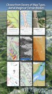
Choose between 30+ map layers (topos, aerials, sea charts, ...) to plan the perfect trip and
turn your Andoid Phone/Tablet into an outdoor GPS for offline trips into the backcountry.
*** Note: Please use Canada Base Map, Toporama or OpenStreetMap layer if you need most recent topo maps ! ***
Add easily maps from other sources (GeoPDF, GeoTiff, Online Map Services like WMS, ...)
Available base map layers for Canada:
• Topomaps Canada (CanMatrix, seamless coverage at scales 1:50.000 and 1:250.000), incl. USA 1:24.000 - 1:250.000), > 30.000 maps
• Canada Basemap CBMT (CanVec, NTDB, Atlas of Canada)
• Toporama Maps Canada in EN&FR (CanVec, NTDB, Atlas of Canada)
• CanTopo (new Canada Topos at 1:50.000, partial coverage of Canada, mainly in the North)
• Ontario LIO Topo Maps
• Québec Topo Maps 1:20.000
• Saskatchewan Orthophotos
• Nova Scotia Othophotos
• British Columbia Topo Maps
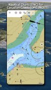
• Nautical Charts ENC
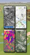
• Digital Elevation Model
• HRDEM (HiRes Elevation Model, parts of Canada)
Worldwide basemap layers:
• OpenStreetMaps (5 different map layouts), also downloadable in space saving vectorformat
• Google Maps (Satellite images, Road- and Terrain-Map)
• Bing Maps (Satellite images, Road-Map)
• Waze Roads
• Earth At Night
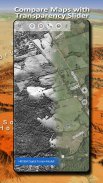
Configure a basemap layer as an overlay and utilize a transparency fader to seamlessly compare maps with each other.
Add maps from other sources:
• Import raster maps in GeoPDF, GeoTiff, MBTiles or Ozi (Oziexplorer OZF2 & OZF3)
• Add web mapping services as WMS or WMTS/Tileserver
• Import OpenStreetMaps in Vectorformat, eg complete USA for just some GBs
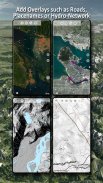
Available Canada map Overlays - add additional information to any other base map:
• CanVec features such as Transportation, Contourlines, Hydronetwork, Toponymic Features, etc.
• Nova Scotia Roads
• Yukon Transportation
Available worldwide overlays:
• Hillshading overlay
• 20m Contourlines
• OpenSeaMap
There is no perfect map. Toggle between the different map layers or use the compare maps feature to find the most interesting route. Especially the old CanMatrix Topos contain many small pathes or other features that are missing on modern maps.
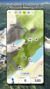
Main features for outdoor-navigation:
• Download map data for OFFLINE USAGE
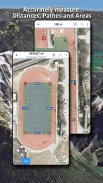
• Measure pathes and aereas
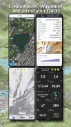
• Create and edit Waypoints
• GoTo-Waypoint-Navigation
• Create and edit Routes
• Route-Navigation (Point-to-Point Navigation)
• Track Recording (with speed, elevation and accuracy profile)
• Tripmaster with fields for odometer, average speed, bearing, elevation, etc.
• GPX/KML/KMZ Import/Export
• Search (placenames, POIs, streets)
• Get elevation and distance
• Customizable datafields in Map View and Tripmaster (e.g. Speed, Distance, Compass, ...)
• Share Waypoints, Tracks or Routes (via eMail, Dropbox, WhatsApp, ..)
• Use coordinates in WGS84, UTM or MGRS/USNG (Military Grid/ US National Grid),
• Track Replay
• and many more ...
Use this navigation app for outdoor activities like hiking, biking, camping, climbing, riding, skiing, canoeing, hunting, snowmobile tours, offroad 4WD tours or search&rescue (SAR).
Add custom waypoints in longitude/latitude, UTM or MGRS/USNG format with WGS84 datum.
Import/Export/Share GPS-Waypoints/Tracks/Routes in GPX or Google Earth KML/KMZ format.
Canadian topographic maps are enhanced with Atlogis® hillshading and placenames.
Credits for topographic map data: "© Department of Natural Resources Canada. All rights reserved."
Please send questions, comments and feature requests to support@atlogis.com
Canada Topo Maps - Version 7.8.1
(21-05-2025)
Canada Topo Maps - APK Information
APK Version: 7.8.1Package: com.atlogis.camaps.freeLatest Version of Canada Topo Maps
Other versions


Apps in the same category


